
Maui History Series · Hāmākualoa, North Maui
Twin Falls & Hoʻolawa: Water, Farm, and Managed Access
Twin Falls is best understood as a visitor name and managed farm entrance within the larger Hoʻolawa watershed—not as a public park or a guaranteed swimming stop.
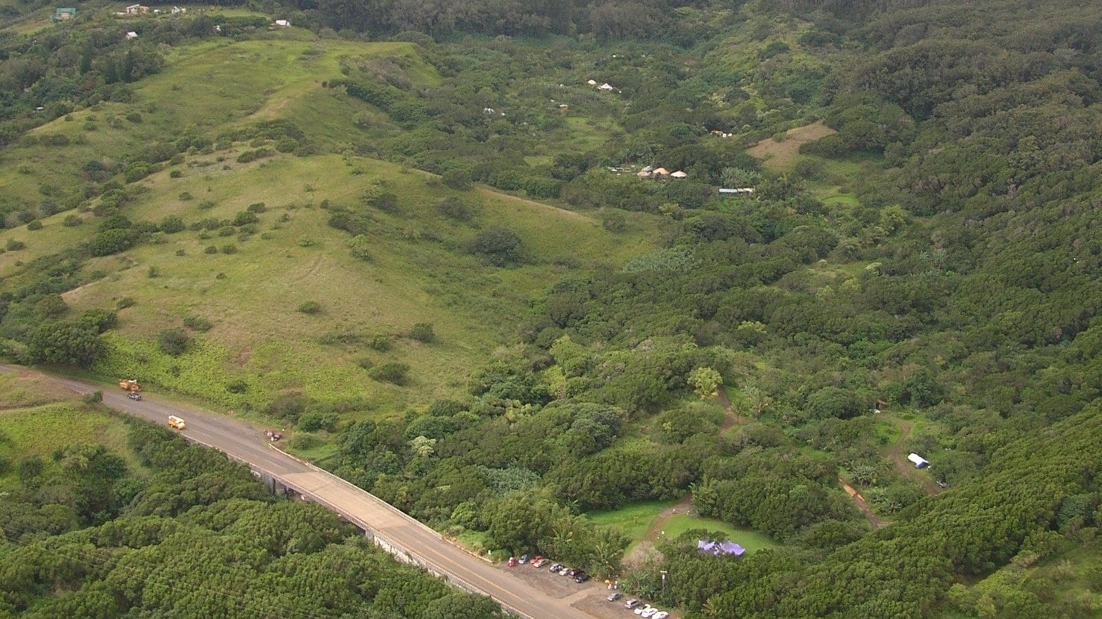
Follow Hoʻolawa through timePhoto: Forest & Kim Starr source (opens in a new tab) · CC BY 3.0 US license (opens in a new tab) · cropped and resized
Start with the watershed
The waterfalls are moving water, not fixed scenery
Hoʻolawa Stream descends the wet windward slope of Haleakalā toward Maui’s north coast. State records describe a roughly 3.6-square-mile drainage with about nine miles along its longest flow path. Rain, diversions, tributaries, groundwater, and storms can all change what reaches any one pool or cascade.
The place commonly marketed as Twin Falls is reached through a privately owned working farm that has managed public access since 1997, according to the operator. The farm entrance, stream, highway bridge, and wider watershed are related, but they are not the same property or authority.
A stream within a larger water system
Hoʻolawa connects windward rain, diversion works, habitat, and the coast
The modern roadside stop makes sense only when placed inside East Maui’s longer land-and-water history.
Do not mistake a modern attraction name for the whole place
County cultural research documents Native Hawaiian relationships among wai, cultivated land, forests, settlement, and the sea across East Maui. Those regional relationships provide essential context for Hoʻolawa without authorizing an invented traditional story for a particular modern trail or waterfall.
This chapter therefore uses Hoʻolawa for the watershed and stream, and Twin Falls for the familiar visitor stop. It does not claim that “Twin Falls” is the traditional name of the stream or either cascade, disclose sensitive places, or imply that customary access and commercial visitor access are interchangeable.
Plantation-era diversions make water a regional story
Hoʻolawa became part of the East Maui diversion network built to move windward water toward plantation agriculture. The network later also supported other agricultural and municipal uses. Its history is visible less as one roadside artifact than as a lasting rearrangement of where stream water flows.
Modern Commission on Water Resource Management proceedings balance instream habitat, traditional and customary practices, recreation, domestic use, and offstream demand. In 2022, the Commission amended interim instream flow standards for twelve Huelo-area streams, including Hoʻolawa, and later work addressed diversion changes, leaks, and habitat connectivity.
Flow categories do not turn into a daily swimming forecast
State records note that different mapping and biological datasets have classified parts of Hoʻolawa differently. The important lesson for visitors is not which database label wins; it is that legal flow standards and long-term hydrology do not predict conditions at a pool on a particular hour.
A wet windward basin can rise quickly, while a dry period or diversion can reduce visible flow. Trail gates, operator instructions, weather alerts, and what the stream is doing now take priority over photographs and itineraries.
-
Before plantation diversion
Wai connects the windward landscape
East Maui communities understand water through relationships among uplands, cultivation, settlement, streams, and sea.
-
Plantation era
Diversion works redirect stream water
Hoʻolawa enters a regional network carrying windward water toward large-scale agriculture.
-
1997
The farm dates managed public access
Wailele Farm’s first-party history says it began welcoming the public through its property.
-
November 2022
Interim flow standards are amended
The State includes Hoʻolawa in a twelve-stream Huelo water decision.
A working farm manages a popular stop
Popularity turns parking and trail access into stewardship questions
The post-plantation story includes diversified farming, visitor pressure, formal access rules, and new community water education.
The operator describes a family farm, not a purpose-built park
Wailele Farm describes itself as a privately owned working farm with hundreds of plant varieties and dates managed public access through the property to 1997. That account is useful for the modern access chapter, but it is a first-party account rather than an independent history of the whole watershed.
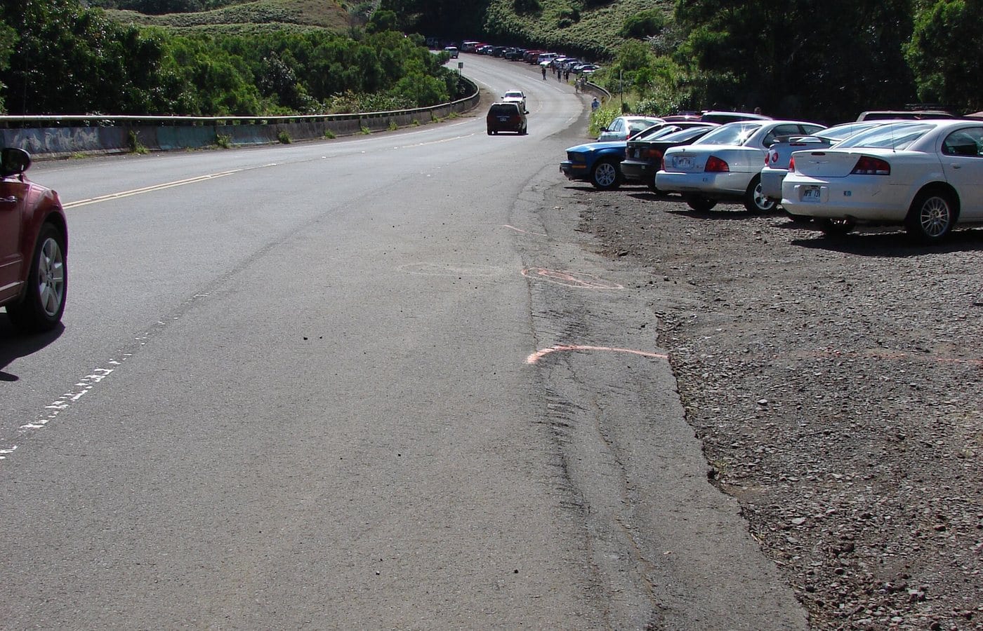
As Twin Falls became a common Road to Hāna stop, limited parking and highway behavior became part of the experience. Current rules direct vehicles into a designated paid lot and reject shoulder parking, walk-ins, ride-share drop-offs, and oversized vehicles. Those rules protect traffic flow as well as private property.
Managed access can close before a visitor arrives
The farm posts gates, last-entry times, daily closing, capacity limits, and a Hawaiʻi-resident day on the first Saturday of each month. It also says weather, staffing, and trail conditions can change operations. A parking space or waterfall view is never guaranteed.
The correct response to a closure is to continue safely—not wait on the highway, walk in from another property, move a barrier, or pressure staff. The same principle applies when the stream is high or a trail is slippery.
A 2026 project links water monitoring and place-based learning
In January 2026, the County’s East Maui Water Authority selected Friends of Twin Falls for a grant supporting Kupu Wai o Hoʻolawa, a yearlong youth and community program focused on water testing, mapping, and place-based learning.
That project brings the history back to its strongest theme. The attraction is temporary and conditional; the watershed is the enduring subject, and caring for it requires observation, education, regulation, and community work.
-
1997
Managed farm access begins
The operator dates the start of public access through private property to this year.
-
2005–2007
Aerial and roadside photographs record the setting
Licensed habitat images show a working landscape, highway bridge, and roadside parking—not a constructed public park.
-
2022–2023
Water implementation continues
State decisions address flow standards, diversion modifications, leaks, and habitat connectivity.
-
2026
Kupu Wai o Hoʻolawa receives support
County funding connects youth water testing, mapping, and place-based learning.
What guests can notice without crossing a boundary
Read the watershed before looking for a photo
The landscape explains why Twin Falls has both strong appeal and strict limits.
- Steep wet slopeCloud, rain, and elevation feed a stream whose conditions can change quickly.
- Highway bridgeHāna Highway crosses the drainage, concentrating traffic near a narrow private entrance.
- Working farmFields and farm operations are part of the place, not empty space around a waterfall.
- Posted barriersA closed gate or trail is current safety and property information, not a suggestion.
Related Maui history & tours
Follow the connections
Continue with the places and experiences that share this chapter’s roads, water, communities, or working landscapes.
Continue the series
Follow water eastward through community and coast
Keʻanae shows a living loʻi and ʻauwai landscape, while Māliko Bay reveals how a neighboring North Shore gulch became a landing, plantation crossing, and exposed launch.
Research notes
Sources & further reading
State and County records establish the watershed, diversion, flow-standard, and 2026 stewardship context. Wailele Farm’s own site supplies current private-property operations and its account of managed access beginning in 1997; those first-party claims are labeled as such. Details were checked August 20, 2026. No commercially usable, accurately attributed close-up waterfall photograph was verified, so this chapter uses licensed aerial and parking-area habitat views and never represents them as the falls.
- County of Maui / Kumu Pono Associates: Maui Hikina cultural and water context (PDF) (opens in a new tab)
- Commission on Water Resource Management: Huelo-area stream and instream-flow records (opens in a new tab)
- Commission on Water Resource Management: Hoʻolawa hydrology and diversion implementation (PDF) (opens in a new tab)
- DLNR: 2022 amended interim instream flow standards for twelve Huelo streams (opens in a new tab)
- CWRM: diversion modifications, leak repairs, and habitat connectivity (opens in a new tab)
- County of Maui East Maui Water Authority: 2026 Kupu Wai o Hoʻolawa grant (opens in a new tab)
- Twin Falls Maui / Wailele Farm: current parking and admission rules (first-party) (opens in a new tab)
- Twin Falls Maui / Wailele Farm: current weather, trail, and access guidance (first-party) (opens in a new tab)
- Wailele Farm: farm and land narrative (first-party) (opens in a new tab)